

INSPIRE téma Rozšířené Parcely (CPX)
| Informace o produktu | ||
|---|---|---|
 | Název | INSPIRE téma Rozšířené Parcely (CPX) |
| Obchodní kód | Obchodní kód není stanoven | |
| Výdejní jednotka | katastrální území | |
| Cena za jednotku | Bez poplatků | |
| Výdejní formáty | GML | |
| Souřadnicové systémy | ETRS89, S-JTSK / Krovak East North | |
| Distribuce | 


| |
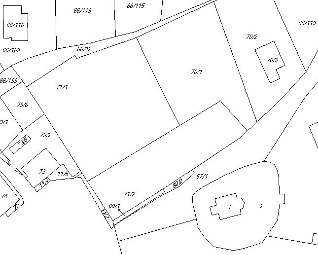
| Popis produktu | Datová sada pro téma Katastrální parcely (CP) harmonizovaná podle směrnice INSPIRE v rozšířeném datovém modelu (CPX). Cílem datové sady je poskytovat úplný obsah katastrální mapy České republiky formou rozšíření datového modelu CP podle pravidel technické dokumentace INSPIRE. Data jsou rozšířena o věcná břemena, bodové pole, další prvky digitální katastrální mapy. Parcely obsahují ve srovnání s datovou sadou INSPIRE některé atributy navíc, jako typ hranice, způsob využití území, druh pozemku, vazbu na budovu na parcele a mapové značky. V datech je také obsažena původní oblouková geometrie hranic parcel. Datová sada je poskytována jako otevřená data (licence CC-BY 4.0). Data vychází z ISKN (Informačního systému katastru nemovitostí). V oblastech s analogovou mapou (rastrová podoba) jsou dostupné pouze definiční body parcel. Hranice katastrálních území jsou dostupné pro celou Českou republiku. Parcely a jejich hranice, věcná břemena, další prvky mapy v území, kde je mapa v digitální formě (k 08. 04. 2024 je to 99,03% území České republiky, t.j. 78 098,22km2). Data se vytvářejí denně (pokud nastane v rámci katastrálního území nějaká změna). Data ve formátu GML 3.2.1 jsou validní proti schématu XML pro Rozšířené Parcely (CPX) ve verzi 4.0. Pro stažení jsou data komprimována (ZIP). Více katastrální zákon 256/2013 Sb., vyhláška o katastru nemovitostí č. 357/2013 Sb., vyhláška o poskytování údajů č. 358/2013 Sb. v platném znění a INSPIRE Data Specification on Cadastral Parcels v 3.0.1. | |
| Aktualizační cyklus - stav aktualizace | Předpřipravené soubory jsou generovány jednou denně. Data získaná službou WFS jsou aktualizována v řádu hodin. | |
| Podmínky přístupu a použití | Podmínky poskytování prostorových dat ČÚZK Licence CC BY 4.0 Veřejný přístup není omezován a je poskytován v souladu s vyhláškou č. 359/2011 Sb., o registru územní identifikace, adres a nemovitostí a zákonem 123/1998 Sb., o právu na informace o životním prostředí. | |
| Prohlížení dat |
Služba WMS | |
| Stahování dat |
Služba WFS Stažení dat z adresáře Služba Atom Stažení předpřipravených souborů - výběr nad mapou | |
| Kontakt - informace o produktu | Český úřad zeměměřický a katastrální, e-mail: cuzk.helpdesk@cuzk.cz | |
Poslední aktualizace produktu:
2024-04-12
2024-04-12
Poslední aktualizace/revize informací:
2024-04-12
2024-04-12
 RSS 2.0 Geoportál ČÚZK